Hiking Mount Viševnik
Hiking in high mountain areas should always be approached with caution. Every hiker must exercise good judgment and self-assessment when considering daily conditions, whether related to the weather, trail difficulty, or personal physical fitness. Mountain conditions can change quickly, so it's essential to be prepared for unexpected challenges. Always carry adequate gear, water, snacks, and a fully charged phone. Let someone know your planned route, and check the weather forecast before you set out. Safety should remain a top priority to fully enjoy the beauty of Slovenia’s landscapes.
Today, our goal is to reach the summit of Mount Viševnik, which rises to 2050 meters in altitude. This loop hike is particularly favored for its combination of impressive panoramas and diverse landscapes. The route, recommended by Slovénie Secrète, is well-detailed and perfect for hikers eager for an immersive high-altitude adventure. Let me know if you'd like to provide more texts for translation!
As mountain hiking enthusiasts, this one ranks among our favorites, alongside the hike we did in the Seven Lakes Valley during the same trip. To discover all our adventures from this day, click on the following link: a fantastic hike in the Seven Lakes Valley (coming soon).
– For our complete Slovenia itinerary, click here: Two Weeks in Slovenia: Itinerary, Tips and Advice –
How to Get to the Pokljuka Plateau?
The Pokljuka plateau is easily accessible by car from Bled or Bohinj. From Bohinj, take route 209 towards Bled, then, after about 1.5 km, turn left towards Pokljuka. Next, turn right onto route 905, continuing in the direction of Pokljuka. As soon as possible, follow the signs for Rudno Polje until you reach the biathlon stadium, where there is a parking and the beginning of numerous hiking trails, including the one leading to Mount Viševnik.
For our stay in Slovenia, we rented a car from Renty, a Slovenian car rental company based in Ljubljana, which we chose for its flexibility and competitive rates.
For those who prefer public transportation, buses also serve the plateau from Bohinj and Bled. You can check bus schedules and fares on the official Bohinj city website.
Where to Stay near the Pokljuka Plateau?
There are a few hotels directly on the Pokljuka plateau. However, we preferred to stay in Bohinj, located a bit lower in the valley. This village offers a variety of accommodation options while being only 20 minutes by car from Pokljuka. Staying in Bohinj allowed us to easily travel between the different points of interest in the area and enjoy a livelier atmosphere in the heart of the valley.
We stayed in an Airbnb located near the lake, along the river by Savica.
A Loop Hike Around Mount Viševnik
Essential Tips
Guide (FR): Slovénie Secrète – an essential resource for exploring the country in depth.
Parking: Paid – located at Rudno Polje, near the Biathlon Stadium. GPS Coordinates: 46°20'38.6"N 13°55'21.4"E.
Hike: A loop of approximately 10 km, with a positive elevation gain of 700 m, of moderate to difficult level. This hike offers beautiful landscapes and allows you to enjoy the fresh mountain air.
Map: The Maps.me app, is essential during my hikes in the great outdoors, and is always with me.
The ascent from the Pokljuka plateau
We leave our car on the Pokljuka plateau, the starting point of our ascent. The trail begins beneath the ski lift cables, a reminder that this mountain turns into a ski resort during the winter. However, today, it is our own strength that will lead us to the summit, through an enchanting landscape that is constantly changing.
The first steps are taken in the shade of the trees, where spruces and pines surround us with their comforting presence. The slope is already quite noticeable, but the coolness of the undergrowth is welcome as we climb slowly but steadily. As we gain altitude, the trees become more sparse, gradually revealing glimpses of the surrounding mountains. The sky seems to widen above us, and the light plays differently on the rock and alpine vegetation.


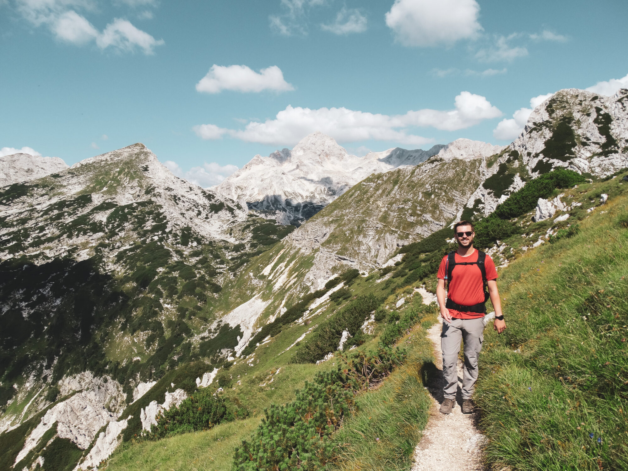
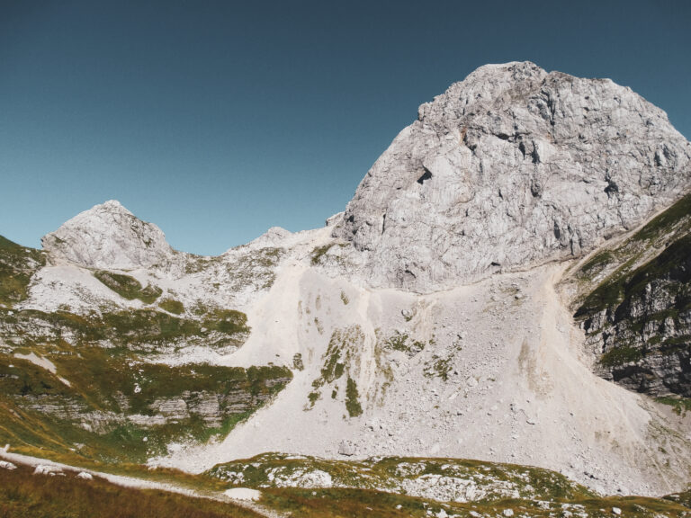
After a little over an hour of climbing, we finally emerge from the forest to find ourselves in an open area. All around us rises a natural amphitheater of majestic peaks. The steep mountains form a true rocky cirque that envelops us, creating a breathtaking landscape where we feel both small and deeply connected to this vastness. The silence is only broken by the wind and, at times, the distant cry of a bird of prey. To our left, the summit of Viševnik appears, bringing us closer to our goal.

The hike gradually becomes more technical, occasionally requiring us to climb over rocks. I would advise against this route for those suffering from vertigo or lacking mountain experience. The increasingly rocky path demands more effort and concentration. Yet, every break is a true reward for the eyes. Soon, we reach the ridge, unveiling spectacular panoramas: the Julian Alps stretch as far as the eye can see. In the distance, the imposing silhouette of Triglav, Slovenia's iconic peak, stands tall, proudly dominating the landscape of the national park that bears its name.


Reaching the Summit of Mount Viševnik
Finally, after two hours of intense effort, we reach the summit of Viševnik. The sense of satisfaction that washes over us is immense. The panoramic view surrounding us is a true reward. It’s a moment of fulfillment, where the effort fades away to make room for contemplation... and hunger! We unpack our picnic, alone at the summit, in harmony with nature, savoring the peace and beauty of the place.


Gradually, we leave the ridge to take a more enclosed path, bordered by small, dense fir trees that partially block the view, making this section of the descent more intimate and silent. Despite this, at times, through the trees, we catch glimpses of the Rudno Polje plateau below. With a little imagination, we could almost spot the silhouette of our car, waiting patiently for our return.

